

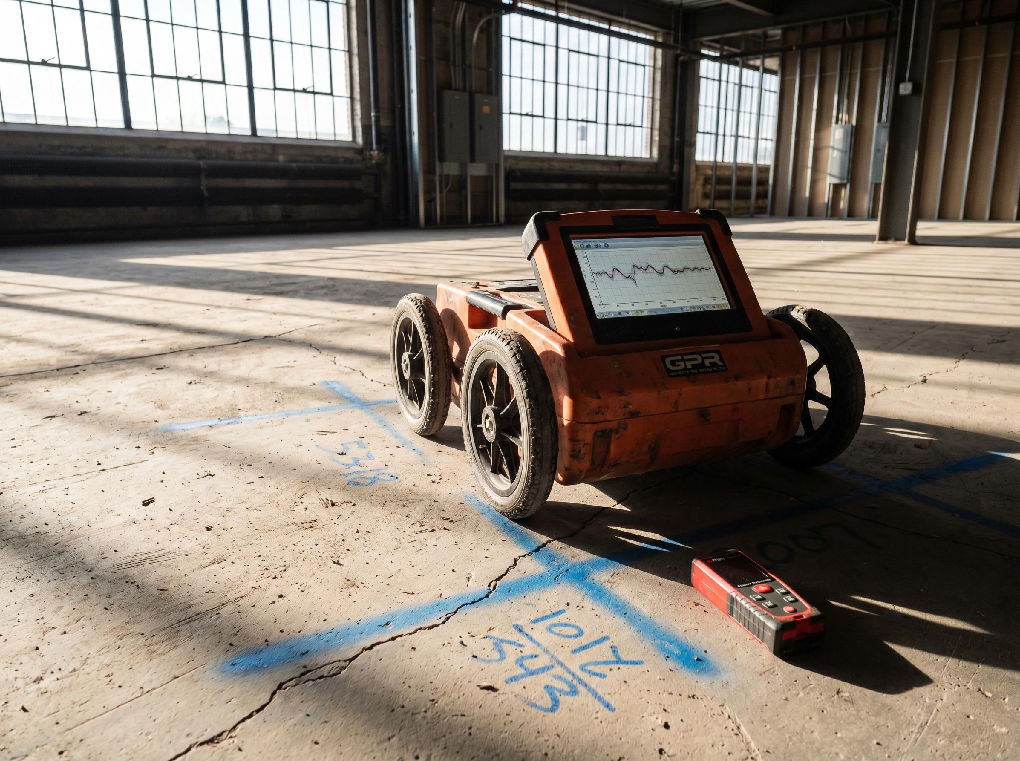
GPR signal penetration through a concrete slab showing hyperbolic reflections from rebar and embedded utilities
The Phoenix metro area ended 2025 with 226,800 construction jobs on its payroll, the highest share of any major U.S. city at 8.4 percent of total employment. Arizona’s road construction starts are projected at $6.5 billion in 2026 alone, up from an average of roughly $1.5 billion per year between 2021 and 2025. These numbers reflect a construction boom that brings both economic opportunity and significant subsurface risk. Every foundation excavation, utility trench, and roadway corridor crosses unknown underground assets: gas lines, fiber optics, water mains, electrical conduits, and post-tension cables. Hitting any one of them can stop a project, injure workers, and cost tens of thousands of dollars.
Ground penetrating radar (GPR) has emerged as the primary non-destructive tool for seeing what lies beneath before the first cut is made. Its ability to map rebar, conduits, and voids in concrete, and to locate buried utilities across soil types, has turned GPR from a specialty service into a standard pre-construction step. This article examines the technology behind modern GPR scanning, its economic justification, and why fast-growing markets such as Phoenix are driving demand for these services.
The Expanding Role of GPR in Modern Construction
Ground-penetrating radar works by transmitting electromagnetic pulses into the ground and recording reflections from buried objects and material boundaries. The time delay and amplitude of these return signals reveal the depth, size, and composition of what lies below. For concrete, operators can map rebar grids, locate post-tension cable sheaths, identify embedded conduits, and detect voids or delamination. In utility locating, the same technology locates buried pipes, conduits, and storage tanks beneath soil, asphalt, and grass.
The construction industry has moved GPR from a niche verification tool to a standard prerequisite for concrete cutting, coring, and excavation. Project owners and general contractors now routinely contract GPR scanning before any slab penetration occurs. That change reflects both the cost of accidental strikes and the reliability of modern multi-channel GPR arrays. In markets such as Phoenix, where semiconductor plants, data centers, and highway expansions run on tight timelines, finding a GPRS Phoenix provider who can deliver same-day scans for concrete slabs and utility corridors has become a normal part of pre-construction planning.
Concrete Scanning: Methodology and Applications
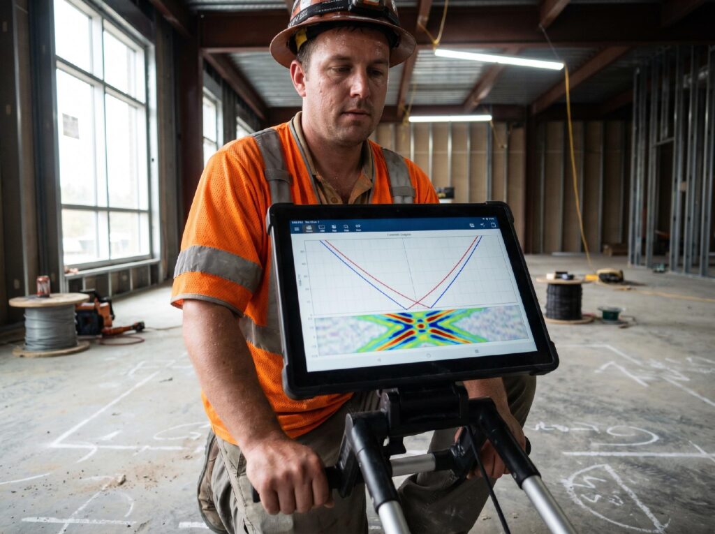
GPR scanning equipment detects post-tension cables embedded in concrete before coring or cutting
Concrete scanning with GPR uses antenna frequencies ranging from 900 MHz to 2.6 GHz, depending on the required depth and resolution. Lower frequencies penetrate deeper, up to about 80 centimeters in dense concrete, but with reduced resolution. Higher frequencies produce sharper images at shallower depths, making them ideal for rebar mapping and thin-slab evaluation. Operators trained in radargram interpretation can distinguish between rebar, post-tension cables, conduits, and voids by analyzing the shape and amplitude of hyperbolic reflections in the scan data.
A 2025 study published in Scientific Reports demonstrated that coupling GPR imaging with an attention-based YOLOv5 deep learning model enables real-time defect detection for UAV-mounted concrete scanning. That combination allows automated classification of subsurface features without requiring an expert interpreter on site. The same techniques that support structural health monitoring of bridges and buildings apply directly to pre-construction assessment of concrete. Our earlier work on structural health monitoring technologies covers the AI-based inspection framework that makes this possible.
Phoenix: A Case Study in Construction-Driven Demand

Phoenix skyline construction activity driven by semiconductor and data center megaprojects
The national market for concrete GPR scanning was estimated at $118.6 million in 2025, according to GII Research and Markets, and is projected to reach $223.5 million by 2032. That 9.47 percent compound annual growth rate is driven largely by the same forces reshaping Phoenix construction. Maricopa County saw monthly manufacturing construction starts climb from $14.7 million in October 2020 to $2.7 billion in October 2025, a surge tied directly to TSMC’s $40 billion semiconductor fabrication complex and Amkor’s $7 billion advanced packaging facility.
As these megaprojects move from site preparation to structural construction, the demand for concrete scanning and private utility locating grows in proportion. Every slab-on-grade foundation, every equipment pad, and every underground utility trench requires verification before concrete placement. A 2026 ConstructConnect analysis of Arizona’s construction forecast notes that the state’s road and highway starts alone are projected at $6.5 billion, creating thousands of linear miles of corridor that need utility locating before construction. Our study on urban infrastructure project timeline analysis documents how undetected subsurface utilities are a leading cause of delay in these environments.
The Economic Case for GPR-Based Utility Locating
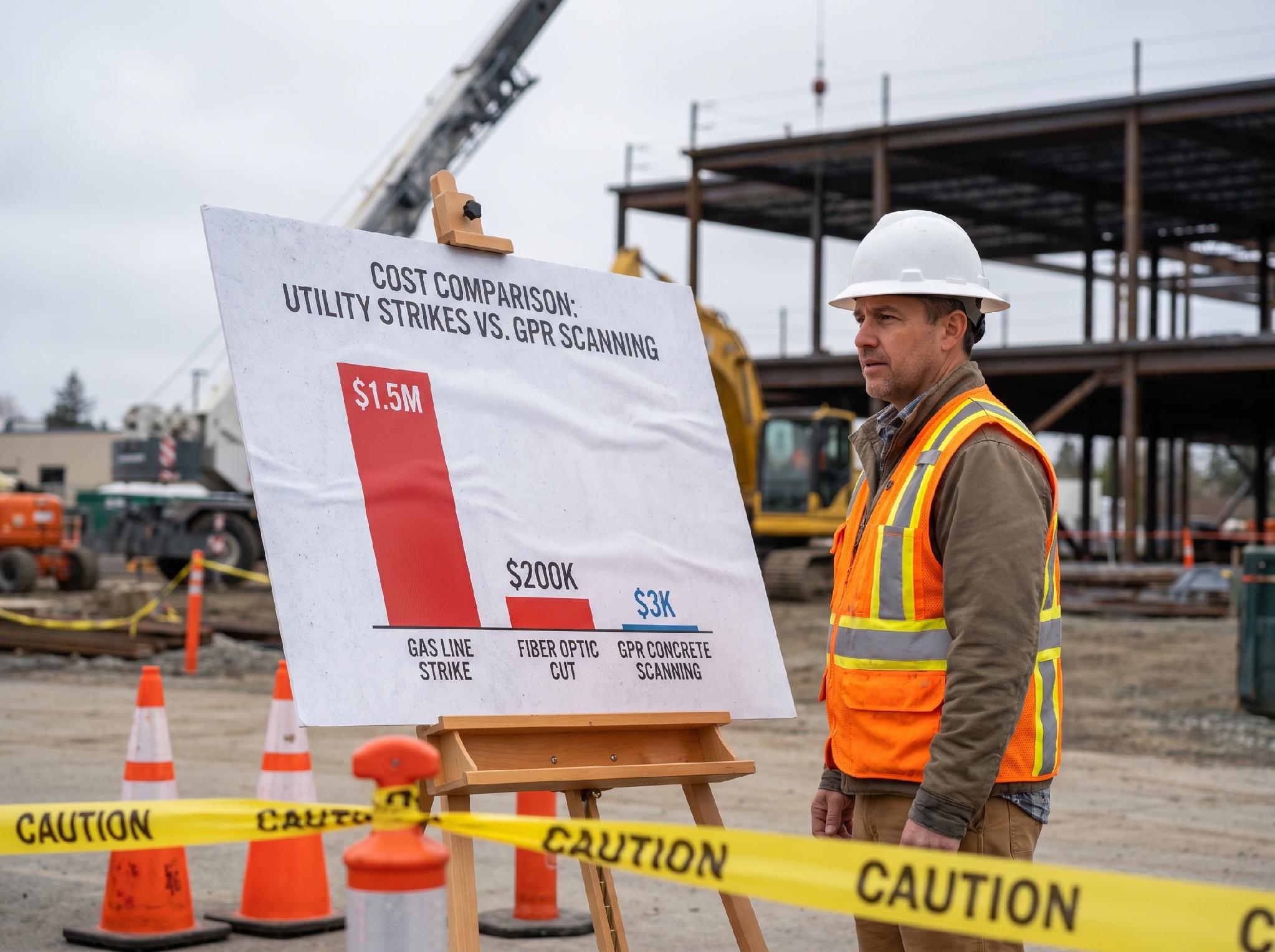
Average total cost of utility strikes by type compared to the typical costs of concrete scanning services
The Common Ground Alliance estimates that between 400,000 and 700,000 underground utility strikes occur each year in the United States at a total economic cost of roughly $30 billion. The average single strike costs somewhere around $56,000 when you factor in repair, downtime, injury liability, and regulatory fines. Compare that to the cost of a typical GPR concrete scan, which ranges from $250 to $1,500 depending on slab area and site conditions. Even at the high end of scanning costs, the economics favor scanning by a wide margin.
The problem is not simply that utilities are buried and forgotten. The CGA’s DIRT report data show that roughly 67 percent of utility strikes happen because the marked utility lies two or more feet from its documented location. As-built drawings are often inaccurate, and utility records can be decades old. GPR provides a direct measurement of what’s actually in the ground, not what a map says should be there. Our research on sustainable concrete infrastructure addresses how non-destructive evaluation supports longer service life for built assets, and pre-construction scanning is the first step in that process.
Emerging Technologies in GPR and Non-Destructive Testing
Several technology trends are expanding what GPR can do on a construction site. Multi-channel antenna arrays now allow operators to cover an entire concrete slab in a single pass rather than walking line by line, cutting field time by 60 percent or more. UAV-mounted GPR systems, though still early in commercial deployment, promise access to vertical structures and hazardous terrain that ground-based surveys cannot reach. The Scientific Reports study mentioned earlier demonstrates that AI models running on edge hardware can classify defects in real time during data collection, eliminating the weeks-long delay between field survey and office interpretation.
Sensor fusion is another frontier. Combining GPR data with ultrasonic tomography, infrared thermography, and LiDAR point clouds produces a composite subsurface model that exceeds what any single modality can deliver. At ConExpo 2026, the RodRadar and Xwatch collaboration demonstrated an excavator-mounted radar system that automatically stops the bucket before striking a buried utility, bringing real-time hazard detection to the operator cab. Fortune Business Insights projects the global GPR market reaching $1.2 billion by 2034, with North America accounting for 38.3 percent of that total.
Conclusion
The construction industry’s relationship with subsurface risk is changing. In high-growth markets such as Phoenix, where the scale and pace of building leave no room for unplanned utility strikes, GPR concrete scanning and utility locating have moved from optional to essential. The technology is improving rapidly, and the economic case for scanning before cutting has never been stronger.
For engineers, project managers, and construction professionals, the takeaway is straightforward: the cost of scanning is small, the cost of a strike is high, and the tools now available give you a reliable picture of what lies beneath before you break ground. Integrating GPR scanning into the standard pre-construction workflow reduces risk, prevents delays, and protects workers and equipment on-site.
